Tour Wandern The Municipal District of Greystones - Greystones à Bray variante  - Photo
 Morelli
Morelli

Benutzer

© OpenStreetMap contributors
Länge
Länge
11,2 km
Maximale Höhe
Maximale Höhe
231 m
Positive Höhendifferenz
279 m
Km-Effort
Km-Effort  
15 km
Min. Höhe
Min. Höhe
0 m
Negative Höhendifferenz
281 m
Boucle
Boucle
Nein
Erstellungsdatum :
2024-09-26 09:08:33.743
Letzte Änderung :
2024-09-26 12:24:28.851

(0 Nachricht)

Wandern
Wandern
2h36
Schwierigkeit : Medium

Scannen Sie diesen QR-Code, um die Tour in der SityTrail-Anwendung zu öffnen

Kostenlosegpshiking-Anwendung

Logo SityTrail SityTrail

IGN / Geografische Institute

SityTrail aus dem App Store herunterladen SityTrail von Google Play herunterladen

Logo SityTrail SityTrail World

Die Welt öffnet sich für Sie

SityTrail aus dem App Store herunterladen SityTrail von Google Play herunterladen SityTrail auf Huawei AppGallery herunterladen

Über SityTrail

Tour Wandern von 11,2 km verfügbar auf Unbekannt, County Wicklow, The Municipal District of Greystones. Diese Tour wird von Morelli vorgeschlagen.

Beschreibung

Attention sentier côtier des falaises fermé

Höhenprofil

Ort

Land:
Ireland
Region :
Unbekannt
Abteilung/Provinz :
County Wicklow
Kommune :
The Municipal District of Greystones
Standort:
Greystones
Gehen Sie:(Dec)
Gehen Sie:(UTM)
696576 ; 5892410 (29U) N.

Touren in der Umgebung

Tour Zu Fuß Unbekannt - Bray Greystones Cliff Walk - Photo
Zu Fuß
GUIDE+

Zu Fuß

Einfach
Unbekannt, Unbekannt, Unbekannt, Ireland
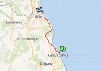
5,8 km | 7,2 km-effort
1h 38min
Nein
Tour Zu Fuß The Municipal District of Greystones - Delgany Heritage Trail - Photo
Zu Fuß
GUIDE+

Zu Fuß

Einfach
The Municipal District of Greystones, Unbekannt, County Wicklow, Ireland
4,6 km | 6,1 km-effort
1h 22min
Ja


Schließen
Meine Abonnements